


 24/7 Emergency Service
How a Jet Stream predict storms
10/30/2020 (Permalink)
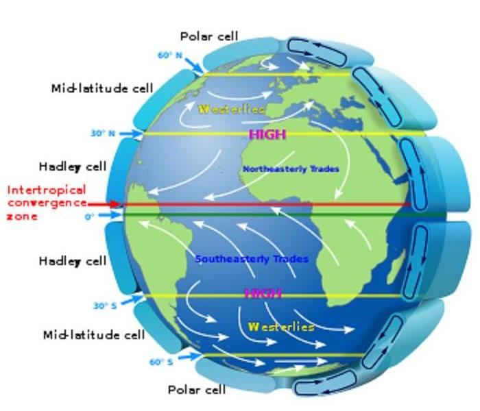 Model of Jet Stream, cell, latitude, temperature
Jet streams play a key role in determining the weather due to the separation of colder and warmer air. They generally push air masses around, moving weather systems to new areas and causing them to stall. The stream is an area of strong winds ranging from 120-250 mph that can be thousands of miles long, a couple of hundred miles across and a few miles deep. The jet streams form when warm air masses meet cold air masses in the atmosphere. On Earth, the main jet streams are located near the altitude of the tropopause and are westerly winds. Their paths typically have a meandering shape.
Jet streams are the major means of transport for weather systems. Without a jet the whole pattern of global temperatures would be different. The air would cool much more gradually across the latitudes. The striking temperature difference between the equator and poles would be gone. The sun does not heat the Earth evenly causing area near the equator to be hot and those near the pole to be cold.
The earth’s rotation is responsible for the jet stream as well. The spinning nature of the earth accentuates these changes. Storms are guided in a generally west-to-east fashion due to jet streams. The weather would change very little without it. Although many factors combine to influence weather, the four main ones are solar radiation, latitude, temperature, and air pressure. The two jet streams that directly affect our weather in the continental US are the polar jet and the subtropical jet. They are responsible for transporting the weather systems that affect us.
If you can predict the path of the jet stream, the upper atmosphere’s undulating river of wind, then you can predict weather. The jet stream can be a prediction for an entire season. Storms ride along the stream and when it shifts so does the area where the storms are the strongest.
Having ways to predict weather can better prepare us for strong storms and flooding. With preparation leads to less cost on home repairs and a weather ready home. Although disasters will happen, and unforeseen damage will occur your SERVPRO of the Quad Cities is always Storm Ready. Professional highly trained technicians are ready to assist in your mitigation and restoration emergencies. Call today for your inspection and estimate on any storm damage your home may have received. Faster to any Disaster saving your home from further damage. SERVPRO of the Quad Cities nearby and ready to help with 24/7 service.